IMAGES TAKEN NEAR TO
Rothienorman, INVERURIE, AB51 8YB
Introduction
This page details the photographs taken nearby to AB51 8YB by members of the Geograph project.
The Geograph project started in 2005 with the aim of publishing, organising and preserving representative images for every square kilometre of Great Britain, Ireland and the Isle of Man.

There are currently over 7.5m images from over14,400 individuals and you can help contribute to the project by visiting https://www.geograph.org.uk
Image Map
Images are licensed for reuse under creativecommons.org/licenses/by-sa/2.0
Notes
- Clicking on the map will re-center to the selected point.
- The higher the marker number, the further away the image location is from the centre of the postcode.
Image Listing (8 Images Found)
Images are licensed for reuse under creativecommons.org/licenses/by-sa/2.0
Image
Details
Distance
1
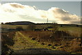
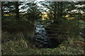
Farm track to West Haughs
There is a newly graded track about 50 metres west of this one.
Image: © Steven Brown
Taken: 23 Jan 2008
0.06 miles
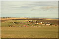
5
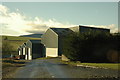
Cowley
The farm and industrial buildings at Cowley
Image: © Steven Brown
Taken: 23 Jan 2008
0.23 miles
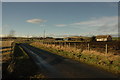
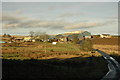
6
Looking across the fields to the farm and industrial buildings at Cowley
Image: © Steven Brown
Taken: 23 Jan 2008
0.23 miles