IMAGES TAKEN NEAR TO
Rothienorman, INVERURIE, AB51 8UT
Introduction
This page details the photographs taken nearby to AB51 8UT by members of the Geograph project.
The Geograph project started in 2005 with the aim of publishing, organising and preserving representative images for every square kilometre of Great Britain, Ireland and the Isle of Man.

There are currently over 7.5m images from over14,400 individuals and you can help contribute to the project by visiting https://www.geograph.org.uk
Image Map
Images are licensed for reuse under creativecommons.org/licenses/by-sa/2.0
Notes
- Clicking on the map will re-center to the selected point.
- The higher the marker number, the further away the image location is from the centre of the postcode.
Image Listing (9 Images Found)
Images are licensed for reuse under creativecommons.org/licenses/by-sa/2.0
Image
Details
Distance
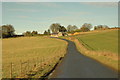
1
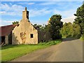
Roadside Ruin
A ruined cottage in Cross of Jackston.
Image: © Andrew Wood
Taken: 17 Aug 2018
0.04 miles
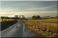
3
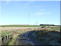
Minor road heading east from Cross Of Jackston
Image: © JThomas
Taken: 9 Nov 2013
0.10 miles
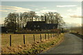
6
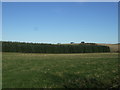
Farmland and woodland
Near Cross Of Jackston.
Image: © JThomas
Taken: 9 Nov 2013
0.11 miles
8
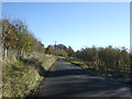
Minor road heading towards Cross of Jackston
Image: © JThomas
Taken: 9 Nov 2013
0.19 miles
9
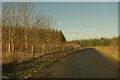
Country road north of Cross of Jackston
Image: © Steven Brown
Taken: 23 Jan 2008
0.21 miles