IMAGES TAKEN NEAR TO
Cromlet Park, INVERURIE, AB51 8SL
Introduction
This page details the photographs taken nearby to Cromlet Park, AB51 8SL by members of the Geograph project.
The Geograph project started in 2005 with the aim of publishing, organising and preserving representative images for every square kilometre of Great Britain, Ireland and the Isle of Man.

There are currently over 7.5m images from over14,400 individuals and you can help contribute to the project by visiting https://www.geograph.org.uk
Image Map
Images are licensed for reuse under creativecommons.org/licenses/by-sa/2.0
Notes
- Clicking on the map will re-center to the selected point.
- The higher the marker number, the further away the image location is from the centre of the postcode.
Image Listing (2 Images Found)
Images are licensed for reuse under creativecommons.org/licenses/by-sa/2.0
Image
Details
Distance
1
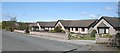
St Katherine's
A trio of lookalike bungalows make up most of the street in the hamlet of St Katherine's.
Image: © Anne Burgess
Taken: 7 May 2009
0.06 miles
2
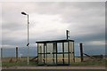
St Katherines Shelter
The roadside bus shelter at St. Katherines.
Image: © Andrew Wood
Taken: 23 Apr 2017
0.15 miles