IMAGES TAKEN NEAR TO
Tillyfourie, INVERURIE, AB51 7SA
Introduction
This page details the photographs taken nearby to AB51 7SA by members of the Geograph project.
The Geograph project started in 2005 with the aim of publishing, organising and preserving representative images for every square kilometre of Great Britain, Ireland and the Isle of Man.

There are currently over 7.5m images from over14,400 individuals and you can help contribute to the project by visiting https://www.geograph.org.uk
Image Map
Images are licensed for reuse under creativecommons.org/licenses/by-sa/2.0
Notes
- Clicking on the map will re-center to the selected point.
- The higher the marker number, the further away the image location is from the centre of the postcode.
Image Listing (12 Images Found)
Images are licensed for reuse under creativecommons.org/licenses/by-sa/2.0
Image
Details
Distance
1
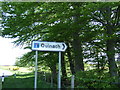
Cul de Sac
Signpost on the Aberdeen-Alford road, pointing the way up the Quinach Burn to Redwell.
Image: © Stanley Howe
Taken: 18 May 2007
0.04 miles
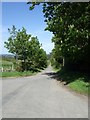
2
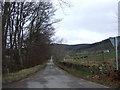
Road to Redwell
From A944 at Causeyton.
Image: © Stanley Howe
Taken: 3 Apr 2007
0.06 miles
3
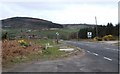
A944 westbound
From layby with telephone kiosk in Millbank. Tillyfourie Hill (361m) in the left background.
Image: © Stanley Howe
Taken: 3 Apr 2007
0.08 miles
4
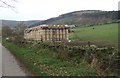
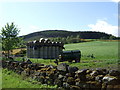
Bales outside Causeyton farm in Autumn
White Hill [NJ6310] at 368m above sea level, and Leybrae Wood (now partly felled), in the background.
Image: © Stanley Howe
Taken: 7 Nov 2007
0.08 miles
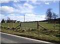
5
Bales outside Causeyton farm in Spring
On Quinach Road.
Image: © Stanley Howe
Taken: 18 May 2007
0.12 miles
8
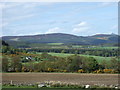
A northerly view from above Quinach
Mither Tap is visible in the far right at a range of c.10km.
Image: © Stanley Howe
Taken: 18 May 2007
0.19 miles
10
Access to Leybrae
From the Quinach Road.
Image: © Stanley Howe
Taken: 18 May 2007
0.22 miles