IMAGES TAKEN NEAR TO
Ordhead, INVERURIE, AB51 7RB
Introduction
This page details the photographs taken nearby to AB51 7RB by members of the Geograph project.
The Geograph project started in 2005 with the aim of publishing, organising and preserving representative images for every square kilometre of Great Britain, Ireland and the Isle of Man.

There are currently over 7.5m images from over14,400 individuals and you can help contribute to the project by visiting https://www.geograph.org.uk
Image Map
Images are licensed for reuse under creativecommons.org/licenses/by-sa/2.0
Notes
- Clicking on the map will re-center to the selected point.
- The higher the marker number, the further away the image location is from the centre of the postcode.
Image Listing (11 Images Found)
Images are licensed for reuse under creativecommons.org/licenses/by-sa/2.0
Image
Details
Distance
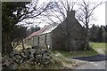
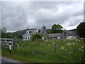
1
Derelict cottage
By B933 approaching Millbank.
Image: © Stanley Howe
Taken: 17 May 2007
0.09 miles
2
Still derelict, but site now for sale
See same building in 2007. Image]
Image: © Stanley Howe
Taken: 9 Oct 2016
0.11 miles
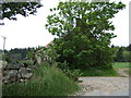
7
Woodside of Shiels
By B933 approaching Millbank.
Image: © Stanley Howe
Taken: 17 May 2007
0.16 miles
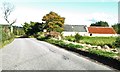
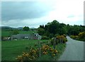
8
Laggan Cottage, Millbank
Dog-leg access track from B993.
Image: © Stanley Howe
Taken: 22 Jul 2018
0.17 miles
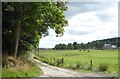
9
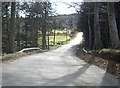
Bridge over Douglas Burn
Near Millbank.
Image: © Stanley Howe
Taken: 26 Mar 2009
0.17 miles
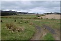
10
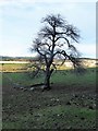
A lone tree
Off B993, in a field opposite Blackstock Wood.
Image: © Stanley Howe
Taken: 24 Nov 2017
0.23 miles