IMAGES TAKEN NEAR TO
Ordhead, INVERURIE, AB51 7QS
Introduction
This page details the photographs taken nearby to AB51 7QS by members of the Geograph project.
The Geograph project started in 2005 with the aim of publishing, organising and preserving representative images for every square kilometre of Great Britain, Ireland and the Isle of Man.

There are currently over 7.5m images from over14,400 individuals and you can help contribute to the project by visiting https://www.geograph.org.uk
Image Map
Images are licensed for reuse under creativecommons.org/licenses/by-sa/2.0
Notes
- Clicking on the map will re-center to the selected point.
- The higher the marker number, the further away the image location is from the centre of the postcode.
Image Listing (4 Images Found)
Images are licensed for reuse under creativecommons.org/licenses/by-sa/2.0
Image
Details
Distance
1
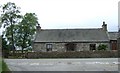
'Roadside Croft'
By the Aberdeen to Alford road, near Ordhead.
Image: © Stanley Howe
Taken: 17 May 2007
0.09 miles
2
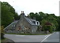
Cottage at Cluny junction
On main road Alford to Aberdeen, east of Ordhead.
Image: © Stanley Howe
Taken: 17 May 2007
0.10 miles
3
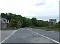
Cluny signpost east of Ordhead
The A-road from Alford to Aberdeenshire suffering here from economy of maintenance, and beginning to look like a patchwork quilt.
Image: © Stanley Howe
Taken: 17 May 2007
0.14 miles
4
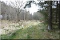
Clearing, Ordhead Wood
The faint grassy track was very well defined in 2009 Google imagery. Old maps show a sawmill at the other end.
Image: © Richard Webb
Taken: 5 Apr 2017
0.17 miles