IMAGES TAKEN NEAR TO
Midmar, INVERURIE, AB51 7QL
Introduction
This page details the photographs taken nearby to AB51 7QL by members of the Geograph project.
The Geograph project started in 2005 with the aim of publishing, organising and preserving representative images for every square kilometre of Great Britain, Ireland and the Isle of Man.

There are currently over 7.5m images from over14,400 individuals and you can help contribute to the project by visiting https://www.geograph.org.uk
Image Map
Images are licensed for reuse under creativecommons.org/licenses/by-sa/2.0
Notes
- Clicking on the map will re-center to the selected point.
- The higher the marker number, the further away the image location is from the centre of the postcode.
Image Listing (10 Images Found)
Images are licensed for reuse under creativecommons.org/licenses/by-sa/2.0
Image
Details
Distance
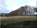
4
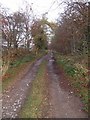
A track ENE from Kebbaty
Through a small wood.
Image: © Stanley Howe
Taken: 12 Nov 2007
0.10 miles
5
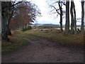
Track junction
Where a northerly tree-lined avenue leaves the track from Ordiefork to Kebbaty.
Image: © Stanley Howe
Taken: 12 Nov 2007
0.11 miles
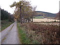
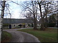
8
A tree-lined avenue
Heading northerly from near Kebbaty.
Image: © Stanley Howe
Taken: 12 Nov 2007
0.20 miles