IMAGES TAKEN NEAR TO
Midmar, INVERURIE, AB51 7PT
Introduction
This page details the photographs taken nearby to AB51 7PT by members of the Geograph project.
The Geograph project started in 2005 with the aim of publishing, organising and preserving representative images for every square kilometre of Great Britain, Ireland and the Isle of Man.

There are currently over 7.5m images from over14,400 individuals and you can help contribute to the project by visiting https://www.geograph.org.uk
Image Map
Images are licensed for reuse under creativecommons.org/licenses/by-sa/2.0
Notes
- Clicking on the map will re-center to the selected point.
- The higher the marker number, the further away the image location is from the centre of the postcode.
Image Listing (32 Images Found)
Images are licensed for reuse under creativecommons.org/licenses/by-sa/2.0
Image
Details
Distance
1
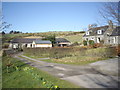
A burn-side track in Comers
Daffodils in bloom on the first day of spring.
Image: © Stanley Howe
Taken: 22 Mar 2012
0.02 miles
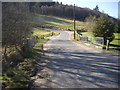
4
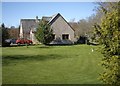
A house by the bridge in Comers
With a spring-mown lawn abutting the road.
Image: © Stanley Howe
Taken: 22 Mar 2012
0.03 miles
5
Crossing the burn in Comers
Road bridge.
Image: © Stanley Howe
Taken: 22 Mar 2012
0.04 miles
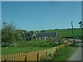
6
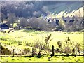
Overlooking Comers
From above Sunnybrae.
Image: © Stanley Howe
Taken: 22 Mar 2012
0.04 miles
7
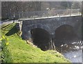
The road bridge in Comers
Upstream face.
Image: © Stanley Howe
Taken: 22 Mar 2012
0.04 miles
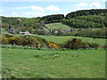
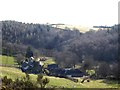
9
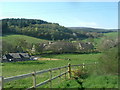
Comers village
From the hill to the west
Image: © Stanley Howe
Taken: 9 May 2006
0.05 miles
10
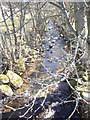
Downstream of the burn through Comers
Seen from the road bridge near Marywell Mill.
Image: © Stanley Howe
Taken: 22 Mar 2012
0.06 miles