IMAGES TAKEN NEAR TO
Sauchen, INVERURIE, AB51 7NX
Introduction
This page details the photographs taken nearby to AB51 7NX by members of the Geograph project.
The Geograph project started in 2005 with the aim of publishing, organising and preserving representative images for every square kilometre of Great Britain, Ireland and the Isle of Man.

There are currently over 7.5m images from over14,400 individuals and you can help contribute to the project by visiting https://www.geograph.org.uk
Image Map
Images are licensed for reuse under creativecommons.org/licenses/by-sa/2.0
Notes
- Clicking on the map will re-center to the selected point.
- The higher the marker number, the further away the image location is from the centre of the postcode.
Image Listing (11 Images Found)
Images are licensed for reuse under creativecommons.org/licenses/by-sa/2.0
Image
Details
Distance
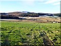
1
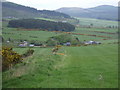
View north over Upper Burnside
From B933 near Mains of Shiels. The White Lady Image at 361m asl, and Green Hill Image at 399m are in the right background.
Image: © Stanley Howe
Taken: 17 May 2007
0.01 miles
2
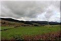
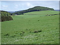
Down to Upper Burnside
Farmland and powerlines leading down to Upper Burnside on the Douglas Burn.
Image: © Andrew Wood
Taken: 28 Aug 2020
0.01 miles
3
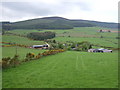
Upper Burnside
Seen from near Blackstock Wood on Millbank-Learney road. Green Hill and part of Corrennie Forest are in the background.
Image: © Stanley Howe
Taken: 17 May 2007
0.02 miles
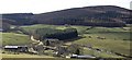
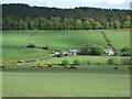
5

A view over the upper Douglas Burn from B993 (Oct 2016)
The high peak on the left is Green Hill (491m asl) with part of Corrennie Forest on its lower slopes. The nearer farmstead in view is Upper Burnside by the Douglas Burn; the one beyond on higher ground is Rowanbush.
Image: © Stanley Howe
Taken: 9 Oct 2016
0.05 miles
6
A view over the upper Douglas Burn from B993 (Nov 2017)
From near Mains of Shiels; towards the snow-capped Green Hill.
Image: © Stanley Howe
Taken: 24 Nov 2017
0.10 miles
7
View towards Upper Burnside
From the track below Rowanbush. Blackstock Wood in the background.
Image: © Stanley Howe
Taken: 18 May 2007
0.15 miles
8
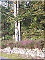
A heatherclad wall by Blackstock Wood
Seen from the B993.
Image: © Stanley Howe
Taken: 29 Aug 2011
0.20 miles
9
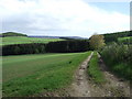
Heading down to Upper Burnside
Knockfullertree Wood in left rear; Hill of Fare on the horizon.
Image: © Stanley Howe
Taken: 18 May 2007
0.21 miles
10
View towards Knockfullertree Wood from near Rowanbush
The wood summit Image is at 297m asl.
Image: © Stanley Howe
Taken: 18 May 2007
0.24 miles