IMAGES TAKEN NEAR TO
Midmar, INVERURIE, AB51 7NN
Introduction
This page details the photographs taken nearby to AB51 7NN by members of the Geograph project.
The Geograph project started in 2005 with the aim of publishing, organising and preserving representative images for every square kilometre of Great Britain, Ireland and the Isle of Man.

There are currently over 7.5m images from over14,400 individuals and you can help contribute to the project by visiting https://www.geograph.org.uk
Image Map
Images are licensed for reuse under creativecommons.org/licenses/by-sa/2.0
Notes
- Clicking on the map will re-center to the selected point.
- The higher the marker number, the further away the image location is from the centre of the postcode.
Image Listing (24 Images Found)
Images are licensed for reuse under creativecommons.org/licenses/by-sa/2.0
Image
Details
Distance
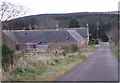
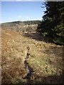
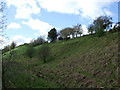
2
Approach to East Bandodle from Comers
Hill of Fare ahead.
Image: © Stanley Howe
Taken: 21 Mar 2012
0.05 miles
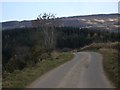
3
Descent from East Bandodle
Towards the crossing of the Bandodle Burn at South Bandodle.
Image: © Stanley Howe
Taken: 21 Mar 2012
0.08 miles
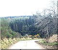
4
Road up to East Bandodle
From the Bandodle Burn.
Image: © Stanley Howe
Taken: 21 Mar 2012
0.10 miles
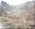
5
Downstream Bandodle Burn
East of the public road.
Image: © Stanley Howe
Taken: 21 Mar 2012
0.10 miles
6
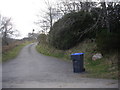
Access lane to South Bandodle
From the Comers to Auchorie minor road.
Image: © Stanley Howe
Taken: 21 Mar 2012
0.10 miles
7
Looking ESE from North Bandodle road junction
Image: © Stanley Howe
Taken: 21 Mar 2012
0.11 miles
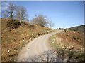
8
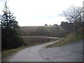
Minor road from Comers to Auchorie
Access to South Bandodle in right foreground.
Image: © Stanley Howe
Taken: 21 Mar 2012
0.13 miles
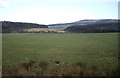
10
Upstream Bandodle Burn at South Bandodle
Seen from the public road.
Image: © Stanley Howe
Taken: 21 Mar 2012
0.16 miles