IMAGES TAKEN NEAR TO
Hallwood Park, INVERURIE, AB51 7NE
Introduction
This page details the photographs taken nearby to Hallwood Park, AB51 7NE by members of the Geograph project.
The Geograph project started in 2005 with the aim of publishing, organising and preserving representative images for every square kilometre of Great Britain, Ireland and the Isle of Man.

There are currently over 7.5m images from over14,400 individuals and you can help contribute to the project by visiting https://www.geograph.org.uk
Image Map
Images are licensed for reuse under creativecommons.org/licenses/by-sa/2.0
Notes
- Clicking on the map will re-center to the selected point.
- The higher the marker number, the further away the image location is from the centre of the postcode.
Image Listing (13 Images Found)
Images are licensed for reuse under creativecommons.org/licenses/by-sa/2.0
Image
Details
Distance
5
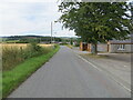
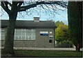
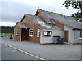
Minor road at Midmar Public Hall
Looking south-westward.
Image: © Peter Wood
Taken: 12 Aug 2021
0.09 miles
7
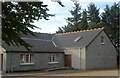
Midmar Parish Hall
On minor road out of Glenwood.
Image: © Stanley Howe
Taken: 27 Oct 2017
0.10 miles
8
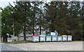
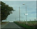
Public Recycling Point, Midmar
Official fly-tip, rainbow coded, outside the village hall.
Image: © Stanley Howe
Taken: 17 May 2007
0.10 miles
9
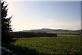
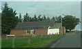
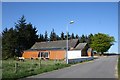
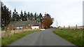
Marywell Wood
Woodland by Midmar taken from behind Midmar Hall.
Image: © Andrew Wood
Taken: 27 Apr 2011
0.15 miles