IMAGES TAKEN NEAR TO
Midmar, INVERURIE, AB51 7LT
Introduction
This page details the photographs taken nearby to AB51 7LT by members of the Geograph project.
The Geograph project started in 2005 with the aim of publishing, organising and preserving representative images for every square kilometre of Great Britain, Ireland and the Isle of Man.

There are currently over 7.5m images from over14,400 individuals and you can help contribute to the project by visiting https://www.geograph.org.uk
Image Map
Images are licensed for reuse under creativecommons.org/licenses/by-sa/2.0
Notes
- Clicking on the map will re-center to the selected point.
- The higher the marker number, the further away the image location is from the centre of the postcode.
Image Listing (32 Images Found)
Images are licensed for reuse under creativecommons.org/licenses/by-sa/2.0
Image
Details
Distance
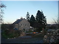
1
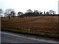
View towards the church
Uphill from B9119.
Image: © Stanley Howe
Taken: 25 Mar 2010
0.04 miles
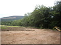
2
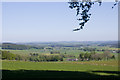
View across the gridsquare
Rich Aberdeenshire farmland with Balblair Farm visible between the trees.
Image: © Bill Harrison
Taken: 31 May 2009
0.09 miles
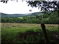
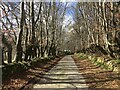
7
Site preparation by road to Balblair
Near B9119 at Midmar.
Image: © Stanley Howe
Taken: 30 Jul 2010
0.16 miles
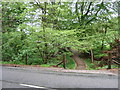
8
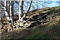
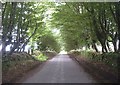
Gnarled Roots
A beech, or is it beeches, clinging to the slope beside the road.
Image: © Anne Burgess
Taken: 20 Apr 2015
0.17 miles
9
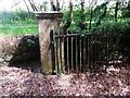
Gateway to Midmar Castle (disused)
Off B9119.
Image: © Stanley Howe
Taken: 21 Jul 2014
0.17 miles
10
Access to Midmar Old Kirk
From Tarland road (B9119).
Image: © Stanley Howe
Taken: 9 May 2007
0.18 miles