IMAGES TAKEN NEAR TO
Sauchen, INVERURIE, AB51 7LR
Introduction
This page details the photographs taken nearby to AB51 7LR by members of the Geograph project.
The Geograph project started in 2005 with the aim of publishing, organising and preserving representative images for every square kilometre of Great Britain, Ireland and the Isle of Man.

There are currently over 7.5m images from over14,400 individuals and you can help contribute to the project by visiting https://www.geograph.org.uk
Image Map
Images are licensed for reuse under creativecommons.org/licenses/by-sa/2.0
Notes
- Clicking on the map will re-center to the selected point.
- The higher the marker number, the further away the image location is from the centre of the postcode.
Image Listing (12 Images Found)
Images are licensed for reuse under creativecommons.org/licenses/by-sa/2.0
Image
Details
Distance
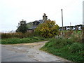
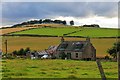
1
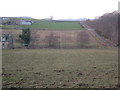
Lyne of Linton
Farm at top left of picture; Blackbaulk Bridge at extreme right.
Image: © Stanley Howe
Taken: 5 Jan 2007
0.01 miles
3
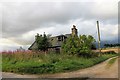
Ruin at Scantcairn
A ruined cottage by the entrance to Benteith Farm.
Image: © Andrew Wood
Taken: 12 Aug 2017
0.15 miles
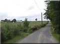
4
Scantcairn
An abandoned cottage, by the entrance to Banteith farm.
Image: © Stanley Howe
Taken: 10 Oct 2007
0.15 miles
5
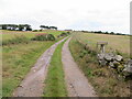
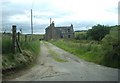
Track that gives access to Banteith
Looking north-eastward.
Image: © Peter Wood
Taken: 12 Aug 2021
0.17 miles
6
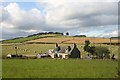
Blackbaulk Croft
Nestling beside Blackbaulk Bridge and the Bethlin burn is this rundown croft.
Image: © Andrew Wood
Taken: 2 Oct 2008
0.18 miles
8
Blackbaulk Croft
A run down wee croft at Blackbaulk.
Image: © Andrew Wood
Taken: 12 Aug 2017
0.19 miles
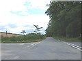
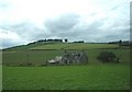
9
Bridge over Bethlin Burn
Lyne of Linton on hill in background.
Image: © Stanley Howe
Taken: 30 Jul 2010
0.20 miles