IMAGES TAKEN NEAR TO
Sauchen, INVERURIE, AB51 7LQ
Introduction
This page details the photographs taken nearby to AB51 7LQ by members of the Geograph project.
The Geograph project started in 2005 with the aim of publishing, organising and preserving representative images for every square kilometre of Great Britain, Ireland and the Isle of Man.

There are currently over 7.5m images from over14,400 individuals and you can help contribute to the project by visiting https://www.geograph.org.uk
Image Map
Images are licensed for reuse under creativecommons.org/licenses/by-sa/2.0
Notes
- Clicking on the map will re-center to the selected point.
- The higher the marker number, the further away the image location is from the centre of the postcode.
Image Listing (6 Images Found)
Images are licensed for reuse under creativecommons.org/licenses/by-sa/2.0
Image
Details
Distance
1
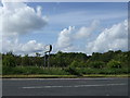
Linton junction
Where Monymusk road via Cluny/Sauchen meets A944.
Image: © Stanley Howe
Taken: 31 May 2007
0.02 miles
2
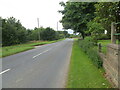
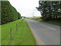
Road (A944) near Kirkwood
Looking westward.
Image: © Peter Wood
Taken: 12 Aug 2021
0.07 miles
3
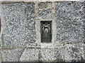
Ordnance Survey Flush Bracket S4946
This bracket can be found on the wall of a former church building at Kirkwood.
The recorded details give a height of 100.8595 above sea level.
For more details see : https://www.bench-marks.org.uk/bm20771
Image: © Peter Wood
Taken: 12 Aug 2021
0.10 miles
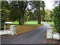
5
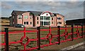
Kirkwood Homes Limited
A striking scarlet fence surrounds a striking office building just outside Sauchen. Also striking is the fact that in mid-afternoon on a Thursday there is only one car parked in the extensive and very recently landscaped grounds.
Image: © Anne Burgess
Taken: 25 Sep 2008
0.15 miles
6
Road (A944) near to Kirkwood
Looking south-eastward.
Image: © Peter Wood
Taken: 12 Aug 2021
0.16 miles