IMAGES TAKEN NEAR TO
Castle Fraser, INVERURIE, AB51 7LJ
Introduction
This page details the photographs taken nearby to AB51 7LJ by members of the Geograph project.
The Geograph project started in 2005 with the aim of publishing, organising and preserving representative images for every square kilometre of Great Britain, Ireland and the Isle of Man.

There are currently over 7.5m images from over14,400 individuals and you can help contribute to the project by visiting https://www.geograph.org.uk
Image Map
Images are licensed for reuse under creativecommons.org/licenses/by-sa/2.0
Notes
- Clicking on the map will re-center to the selected point.
- The higher the marker number, the further away the image location is from the centre of the postcode.
Image Listing (9 Images Found)
Images are licensed for reuse under creativecommons.org/licenses/by-sa/2.0
Image
Details
Distance
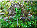
3
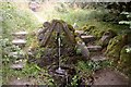
The Old Moses Well at Castle Fraser, Aberdeenshire
Image: © Andrew Tryon
Taken: 25 Aug 2016
0.18 miles
4
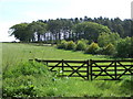
A copse between Greenburn and Achath
From Dunecht to Kemnay road.
Image: © Stanley Howe
Taken: 31 May 2007
0.18 miles
5
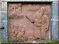
Moses Well, Castle Fraser
Detail of one of the panels, presumably depicting Moses.
Image: © Alan Findlay
Taken: 30 Sep 2008
0.20 miles
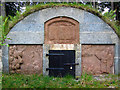
6
Moses Well, Castle Fraser
The outflow from the well.
Image: © Alan Findlay
Taken: 30 Sep 2008
0.20 miles
7
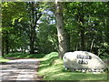
Entrance to Courtcairn farm
Home of 'Fraser Pigs'.
Image: © Stanley Howe
Taken: 31 May 2007
0.21 miles
9
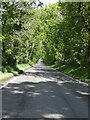
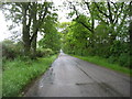
The Dunecht to Kemnay road through Miss Bristow's Wood
Between the South and West lodge entrances to Castle Fraser.
Image: © Stanley Howe
Taken: 31 May 2007
0.23 miles