IMAGES TAKEN NEAR TO
Don View, INVERURIE, AB51 7JE
Introduction
This page details the photographs taken nearby to Don View, AB51 7JE by members of the Geograph project.
The Geograph project started in 2005 with the aim of publishing, organising and preserving representative images for every square kilometre of Great Britain, Ireland and the Isle of Man.

There are currently over 7.5m images from over14,400 individuals and you can help contribute to the project by visiting https://www.geograph.org.uk
Image Map
Images are licensed for reuse under creativecommons.org/licenses/by-sa/2.0
Notes
- Clicking on the map will re-center to the selected point.
- The higher the marker number, the further away the image location is from the centre of the postcode.
Image Listing (15 Images Found)
Images are licensed for reuse under creativecommons.org/licenses/by-sa/2.0
Image
Details
Distance
1
Donview Studio
By the road from Monymusk to My Lord's Throat.
Image: © Stanley Howe
Taken: 15 Nov 2007
0.04 miles
2
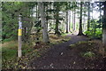
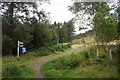
Start of the trail
The paths to Millstone Hill and Bennachie are marked by extra-large direction signs (and I still managed to get lost...)
Image: © Bill Harrison
Taken: 29 Aug 2020
0.04 miles
3
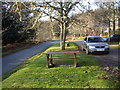
Picnic tables
In the car park at Donview.
Image: © Stanley Howe
Taken: 15 Nov 2007
0.04 miles
4
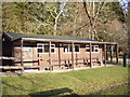
Donview Centre
Donview seasonal information & visitor centre, in the Don valley south of Bennachie, Aberdeenshire. There is a car park and picnic tables.
Image: © Lynette and Malcolm Johnson
Taken: 8 Nov 2004
0.05 miles
5
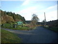
Access to Donview car park
From the Monymusk to Keig road.
Image: © Stanley Howe
Taken: 15 Nov 2007
0.08 miles
6
Through the gate...
...on the way to Millstone Hill.
Image: © Bill Harrison
Taken: 29 Aug 2020
0.08 miles
7
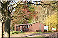
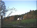
Bennachie Forest at Donview
The hill known as Bennachie dominates the landscape north west of Aberdeen around Inverurie and Oldmeldrum. Its wooded sides offer some excellent walking and scenery. A productive forestry, mostly owned by the Forestry Commission, Bennachie now provides around 10,000 tonnes of timber annually. A seasonal visitor information centre on the southern side, overlooking the River Don, aptly named Donview, has a small car park.
Image: © Lynette and Malcolm Johnson
Taken: 8 Nov 2004
0.13 miles
9
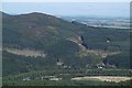
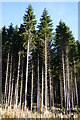
Millstone Hill
The south facing side of the hill.
Image: © Richard Webb
Taken: 17 Sep 2016
0.14 miles
10
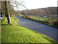
View down the River Don
From by Donview. The avenue of trees along the riverbank is part of the long driveway to Place of Tillyfoure.
Image: © Stanley Howe
Taken: 15 Nov 2007
0.14 miles