IMAGES TAKEN NEAR TO
Monymusk, INVERURIE, AB51 7JD
Introduction
This page details the photographs taken nearby to AB51 7JD by members of the Geograph project.
The Geograph project started in 2005 with the aim of publishing, organising and preserving representative images for every square kilometre of Great Britain, Ireland and the Isle of Man.

There are currently over 7.5m images from over14,400 individuals and you can help contribute to the project by visiting https://www.geograph.org.uk
Image Map
Images are licensed for reuse under creativecommons.org/licenses/by-sa/2.0
Notes
- Clicking on the map will re-center to the selected point.
- The higher the marker number, the further away the image location is from the centre of the postcode.
Image Listing (12 Images Found)
Images are licensed for reuse under creativecommons.org/licenses/by-sa/2.0
Image
Details
Distance
1
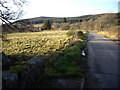
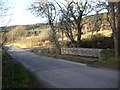
Road to East Glenton
From the bridge over the March Burn.
Image: © Stanley Howe
Taken: 15 Nov 2007
0.06 miles
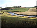
5
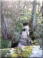
Downstream March Burn
From the road bridge.
Image: © Stanley Howe
Taken: 15 Nov 2007
0.13 miles
7
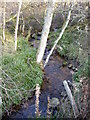
Upstream March Burn
From bridge over Monymusk to Keig road.
Image: © Stanley Howe
Taken: 15 Nov 2007
0.15 miles
9
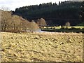
Downstream River Don
From near Glenton.
Image: © Stanley Howe
Taken: 15 Nov 2007
0.21 miles
10
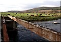
Old Bridge over River Don
The bridge was dismantled in 2005.
Image: © Gilbert Scott
Taken: 12 Nov 2006
0.21 miles