IMAGES TAKEN NEAR TO
Monymusk, INVERURIE, AB51 7HA
Introduction
This page details the photographs taken nearby to AB51 7HA by members of the Geograph project.
The Geograph project started in 2005 with the aim of publishing, organising and preserving representative images for every square kilometre of Great Britain, Ireland and the Isle of Man.

There are currently over 7.5m images from over14,400 individuals and you can help contribute to the project by visiting https://www.geograph.org.uk
Image Map
Images are licensed for reuse under creativecommons.org/licenses/by-sa/2.0
Notes
- Clicking on the map will re-center to the selected point.
- The higher the marker number, the further away the image location is from the centre of the postcode.
Image Listing (3 Images Found)
Images are licensed for reuse under creativecommons.org/licenses/by-sa/2.0
Image
Details
Distance
1
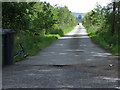
Balvack road
From Sauchen to Monymusk road, near Ton Burn.
Image: © Stanley Howe
Taken: 31 May 2007
0.09 miles
2
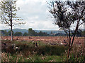
Forestry operations
The aftermath of Forestry operations south of Monymusk, Aberdeenshire
Image: © John Aldersey-Williams
Taken: 22 May 2005
0.11 miles
3
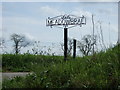
Access to Meadowbrae
From Sauchen to Monymusk road.
Image: © Stanley Howe
Taken: 31 May 2007
0.19 miles