IMAGES TAKEN NEAR TO
Boynds Park, INVERURIE, AB51 6BW
Introduction
This page details the photographs taken nearby to Boynds Park, AB51 6BW by members of the Geograph project.
The Geograph project started in 2005 with the aim of publishing, organising and preserving representative images for every square kilometre of Great Britain, Ireland and the Isle of Man.

There are currently over 7.5m images from over14,400 individuals and you can help contribute to the project by visiting https://www.geograph.org.uk
Image Map
Images are licensed for reuse under creativecommons.org/licenses/by-sa/2.0
Notes
- Clicking on the map will re-center to the selected point.
- The higher the marker number, the further away the image location is from the centre of the postcode.
Image Listing (3 Images Found)
Images are licensed for reuse under creativecommons.org/licenses/by-sa/2.0
Image
Details
Distance
1
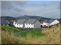
New builds at Boynds Brae
New houses at Boynds Brae on the hillside above Inverurie to the north-east, with Bennachie looming behind.
Image: © Scott Cormie
Taken: 28 Aug 2023
0.02 miles
2
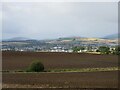
Prepared field above Inverurie
Prepared field on the hillside north-east of Inverurie.
Image: © Scott Cormie
Taken: 28 Aug 2023
0.11 miles
3
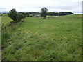
View north from near Hillbrae
On the Bourtie road north-east of Inverurie.
Image: © Jonathan Billinger
Taken: 17 Jul 2007
0.24 miles