IMAGES TAKEN NEAR TO
Boynds Brae, INVERURIE, AB51 6AX
Introduction
This page details the photographs taken nearby to Boynds Brae, AB51 6AX by members of the Geograph project.
The Geograph project started in 2005 with the aim of publishing, organising and preserving representative images for every square kilometre of Great Britain, Ireland and the Isle of Man.

There are currently over 7.5m images from over14,400 individuals and you can help contribute to the project by visiting https://www.geograph.org.uk
Image Map
Images are licensed for reuse under creativecommons.org/licenses/by-sa/2.0
Notes
- Clicking on the map will re-center to the selected point.
- The higher the marker number, the further away the image location is from the centre of the postcode.
Image Listing (4 Images Found)
Images are licensed for reuse under creativecommons.org/licenses/by-sa/2.0
Image
Details
Distance
1
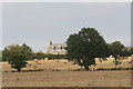
Boynds Farm
Boynds farmhouse enjoying a westerly view over Inverurie.
Image: © Andrew Wood
Taken: 21 Sep 2008
0.14 miles
2
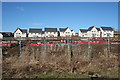
An Ephemeral Scene
This view is evidently not going to last much longer, because before long there will be more houses on the foundations in the foreground. I suppose one advantage of packing the houses in like sardines in a tin is that the eventual occupants won't have to expend much time and money on looking after their gardens. I wonder how the catastrophic downturn in the oil industry is going to affect the house building industry in this area?
Image: © Anne Burgess
Taken: 18 Feb 2016
0.17 miles
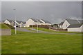
4
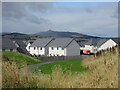
New builds at Boynds Brae
New houses at Boynds Brae on the hillside above Inverurie to the north-east, with Bennachie looming behind.
Image: © Scott Cormie
Taken: 28 Aug 2023
0.22 miles