IMAGES TAKEN NEAR TO
Brae Walk, INVERURIE, AB51 5SD
Introduction
This page details the photographs taken nearby to Brae Walk, AB51 5SD by members of the Geograph project.
The Geograph project started in 2005 with the aim of publishing, organising and preserving representative images for every square kilometre of Great Britain, Ireland and the Isle of Man.

There are currently over 7.5m images from over14,400 individuals and you can help contribute to the project by visiting https://www.geograph.org.uk
Image Map
Images are licensed for reuse under creativecommons.org/licenses/by-sa/2.0
Notes
- Clicking on the map will re-center to the selected point.
- The higher the marker number, the further away the image location is from the centre of the postcode.
Image Listing (3 Images Found)
Images are licensed for reuse under creativecommons.org/licenses/by-sa/2.0
Image
Details
Distance
1
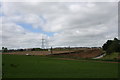
Earth Moving at Blackhall
New building work near Mains of Blackhall marking the steady expansion of Inverurie.
Image: © Andrew Wood
Taken: 4 Jun 2011
0.06 miles
2
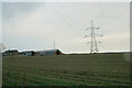
Pylon line to east of Mains of Blackhall Farm.
Image: © Des Colhoun
Taken: 4 Feb 2007
0.08 miles
3
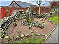
Standing at the side of a road
Standing stone and circle at the side of a roundabout. I suspect that it is not ancient.
Image: © Ralph Greig
Taken: 27 Dec 2021
0.22 miles