IMAGES TAKEN NEAR TO
Craig Lea, INVERURIE, AB51 5QY
Introduction
This page details the photographs taken nearby to Craig Lea, AB51 5QY by members of the Geograph project.
The Geograph project started in 2005 with the aim of publishing, organising and preserving representative images for every square kilometre of Great Britain, Ireland and the Isle of Man.

There are currently over 7.5m images from over14,400 individuals and you can help contribute to the project by visiting https://www.geograph.org.uk
Image Map
Images are licensed for reuse under creativecommons.org/licenses/by-sa/2.0
Notes
- Clicking on the map will re-center to the selected point.
- The higher the marker number, the further away the image location is from the centre of the postcode.
Image Listing (24 Images Found)
Images are licensed for reuse under creativecommons.org/licenses/by-sa/2.0
Image
Details
Distance
1
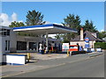
Kemnay Petrol Station, Station Road, Kemnay
It only seems to sell diesel, perhaps to farm vehicles.
Image: © Bill Harrison
Taken: 14 Sep 2013
0.07 miles
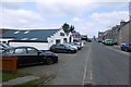
4
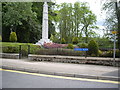
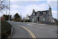
Station Road
This, rather than the High Street, is the principal street in Kemnay.
Image: © Anne Burgess
Taken: 30 Jul 2014
0.08 miles
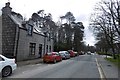
5
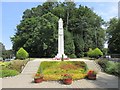
Kemnay War Memorial
The First World War Memorial at Station Road in Kemnay.
Image: © Scott Cormie
Taken: 26 Jul 2018
0.10 miles
7
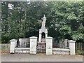
James Mitchell Memorial
In 1840ish travel to and from Kemnay to Aberdeen was by Stage-Coach called ‘The Banks of Don’ which travelled between Inverurie and Aberdeen.
To catch the Stage-Coach you had to walk the Four miles to get to the Inverurie – Aberdeen road. The road from Kemnay did not follow the route of today, but went from the Pleasure Park up past Leschangie rejoining the road of today at Cotton about two miles west of Kemnay.
In these early days Parcels and Goods were delivered to Kemnay by a Local Carrier James Mitchell who could have been seen setting off early in the morning, winding his way round past Leschangie and slowly making his way up the Tyrebagger Hill on his way to Aberdeen. He would make his way back later in the day laden with goods bound for Kemnay and the surrounding area.
James Mitchell could neither read nor write, but he had a good memory and with the careful placing of goods on his cart could deliver them in the most part without error. He also delivered fresh water from a stream that used to run from the drinking fountain on the statue. Sadly it has now been disconnected. James Mitchell was characteristically dressed in Cord Knee length Britches, Broad Blue Hat and Knee length Boots..
The Memorial was erected in 1936 at the West end of Kemnay on the B993 Kintore to Tillyfourie (Alford) road.
Image: © Ralph Greig
Taken: 30 Sep 2023
0.11 miles
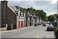
8
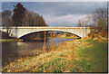
Kemnay Bridge
This bridge spans the River Don and is taken from the south-west. The village is to the right, off picture.
Image: © Colin Smith
Taken: 16 Apr 2006
0.12 miles
9
Bridge Road, Kemnay
Near the site of the railway station on the Alford Valley Line.
Image: © Richard Webb
Taken: 5 Apr 2017
0.12 miles
10
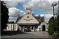
urnett Arms Hotel
This should of course read Burnett Arms Hotel, but the B has apparently been missing for some time. That, plus the banner advertising live sport, was quite enough to deter me from going in for a bite of lunch.
Image: © Anne Burgess
Taken: 30 Jul 2014
0.13 miles