IMAGES TAKEN NEAR TO
Whiteford Gardens, INVERURIE, AB51 5QL
Introduction
This page details the photographs taken nearby to Whiteford Gardens, AB51 5QL by members of the Geograph project.
The Geograph project started in 2005 with the aim of publishing, organising and preserving representative images for every square kilometre of Great Britain, Ireland and the Isle of Man.

There are currently over 7.5m images from over14,400 individuals and you can help contribute to the project by visiting https://www.geograph.org.uk
Image Map
Images are licensed for reuse under creativecommons.org/licenses/by-sa/2.0
Notes
- Clicking on the map will re-center to the selected point.
- The higher the marker number, the further away the image location is from the centre of the postcode.
Image Listing (6 Images Found)
Images are licensed for reuse under creativecommons.org/licenses/by-sa/2.0
Image
Details
Distance
1
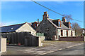
House in Whiteford
A traditional 1½ storey house set back from the main road in Whiteford.
Image: © Anne Burgess
Taken: 17 Mar 2022
0.12 miles
2
Sunnybank
A traditional cottage with two extensions and a plethora of poles and wires around it.
Image: © Anne Burgess
Taken: 17 Mar 2022
0.13 miles
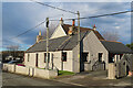
3
Houses in Whiteford
A modern house with a summerhouse in its garden, beside a traditional stone cottage in Whiteford Road.
Image: © Anne Burgess
Taken: 17 Mar 2022
0.13 miles
4
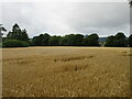
Field near Pitcaple
Looking south-westwards over a field of wheat amidst the woodlands at Pitcaple.
Image: © Scott Cormie
Taken: 4 Sep 2021
0.14 miles
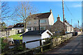
5
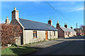
Whiteford
A row of traditional stone cottages on the north side of the main street in Whiteford.
Image: © Anne Burgess
Taken: 17 Mar 2022
0.18 miles
6
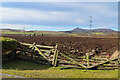
Old Gate
Fortunately this gate is not being called upon to contain livestock in the field. The distinctively shaped hill in the distance is Bennachie (pronounce it 'ben-a HEE', with the stress on the last syllable.)
Image: © Anne Burgess
Taken: 17 Mar 2022
0.21 miles