IMAGES TAKEN NEAR TO
Kemnay, INVERURIE, AB51 5NY
Introduction
This page details the photographs taken nearby to AB51 5NY by members of the Geograph project.
The Geograph project started in 2005 with the aim of publishing, organising and preserving representative images for every square kilometre of Great Britain, Ireland and the Isle of Man.

There are currently over 7.5m images from over14,400 individuals and you can help contribute to the project by visiting https://www.geograph.org.uk
Image Map
Images are licensed for reuse under creativecommons.org/licenses/by-sa/2.0
Notes
- Clicking on the map will re-center to the selected point.
- The higher the marker number, the further away the image location is from the centre of the postcode.
Image Listing (4 Images Found)
Images are licensed for reuse under creativecommons.org/licenses/by-sa/2.0
Image
Details
Distance
1

Aquhythie Pylon
A roadside pylon at Aquhythie near Kemnay.
Image: © Andrew Wood
Taken: 29 Apr 2010
0.19 miles
2
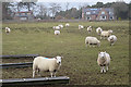
Sheep at Auquhithie
Unusually, when I climbed on to the dyke to get a shot of the sheep, they all starting heading towards me. I suppose they associate the appearance of H sapiens with the arrival of food, and I hope their disappointment was short-lived.
Image: © Anne Burgess
Taken: 14 Mar 2018
0.20 miles
3
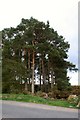
Roadside Pine
Pine trees by the roadside at Aquhythie.
Image: © Andrew Wood
Taken: 29 Apr 2010
0.22 miles
4
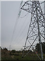
Pylons
One of several power lines that rather dominate the landscape.
Image: © Anne Burgess
Taken: 14 Mar 2018
0.23 miles