IMAGES TAKEN NEAR TO
INVERURIE, AB51 5NT
Introduction
This page details the photographs taken nearby to AB51 5NT by members of the Geograph project.
The Geograph project started in 2005 with the aim of publishing, organising and preserving representative images for every square kilometre of Great Britain, Ireland and the Isle of Man.

There are currently over 7.5m images from over14,400 individuals and you can help contribute to the project by visiting https://www.geograph.org.uk
Image Map
Images are licensed for reuse under creativecommons.org/licenses/by-sa/2.0
Notes
- Clicking on the map will re-center to the selected point.
- The higher the marker number, the further away the image location is from the centre of the postcode.
Image Listing (8 Images Found)
Images are licensed for reuse under creativecommons.org/licenses/by-sa/2.0
Image
Details
Distance
1
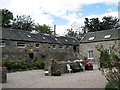
Thainstone Home Farm
Former home farm and stables converted to residential use.
Image: © Mike and Kirsty Grundy
Taken: 24 Jul 2007
0.16 miles
2
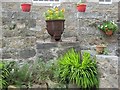
Pot Plants
Former stable yard of farm conversion
Image: © Mike and Kirsty Grundy
Taken: 24 Jul 2007
0.16 miles
3
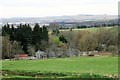
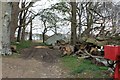
Home Farm
Thainstone Home Farm from higher up Shaw Hill.
Image: © Andrew Wood
Taken: 4 Apr 2017
0.16 miles
5
Felled Trees
Trees awaiting the portable sawmill by Thainstone Home Farm.
Image: © Andrew Wood
Taken: 4 Apr 2017
0.23 miles
6
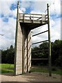
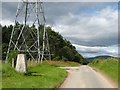
Climbing Tower
Fun for climbers. Not fun for upwardly mobile executives on motivational courses.
Image: © Mike and Kirsty Grundy
Taken: 25 Jul 2007
0.23 miles
7
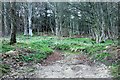
Track into Woods
A track through woodland by Thainstone Home farm.
Image: © Andrew Wood
Taken: 4 Apr 2017
0.24 miles
8
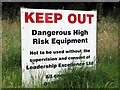
Invitation to Investigate
This refers to the nearby aerial array of climbing, swinging and falling off equipment - see photo titled "Climbing Tower"
Image: © Mike and Kirsty Grundy
Taken: 25 Jul 2007
0.24 miles