IMAGES TAKEN NEAR TO
Pitcaple, INVERURIE, AB51 5HU
Introduction
This page details the photographs taken nearby to AB51 5HU by members of the Geograph project.
The Geograph project started in 2005 with the aim of publishing, organising and preserving representative images for every square kilometre of Great Britain, Ireland and the Isle of Man.

There are currently over 7.5m images from over14,400 individuals and you can help contribute to the project by visiting https://www.geograph.org.uk
Image Map
Images are licensed for reuse under creativecommons.org/licenses/by-sa/2.0
Notes
- Clicking on the map will re-center to the selected point.
- The higher the marker number, the further away the image location is from the centre of the postcode.
Image Listing (7 Images Found)
Images are licensed for reuse under creativecommons.org/licenses/by-sa/2.0
Image
Details
Distance
1
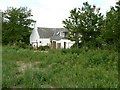
Whitecross Farm
From the field south-east of the farm.
Image: © James Allan
Taken: 16 Jun 2008
0.02 miles
2
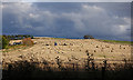
Whitecross
Ominous-looking clouds are gathering on Whitecross Hill as the farm workers gather in the bales of straw.
Image: © Anne Burgess
Taken: 24 Oct 2019
0.06 miles
3
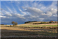
Splendid Sky at Whitecross
The foreground and farm house are in square, but the view is dominated by storm clouds building up over Whitecross Hill.
Image: © Anne Burgess
Taken: 24 Oct 2019
0.10 miles
4
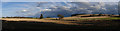
'Panorama' at Whitecross
There's quite a contrast between the serene blue sky on the left and the build-up of cloud on the right.
Image: © Anne Burgess
Taken: 24 Oct 2019
0.14 miles
5

Fields by Whitecross
A grass field by Whitecross and the Hill of Whitecross behind.
Image: © Andrew Wood
Taken: 20 Aug 2011
0.18 miles
6
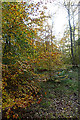
Beech Woods
This strip of woodland is unnamed on the maps.
Image: © Anne Burgess
Taken: 24 Oct 2019
0.23 miles
7
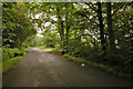
Road and junction
The road from Chapel of Garioch to Blairdaff and the junction with the road to Burnhervie, Aberdeenshire.
Image: © Steven Brown
Taken: 22 Jul 2007
0.25 miles