IMAGES TAKEN NEAR TO
Meikle Wartle, INVERURIE, AB51 5BQ
Introduction
This page details the photographs taken nearby to AB51 5BQ by members of the Geograph project.
The Geograph project started in 2005 with the aim of publishing, organising and preserving representative images for every square kilometre of Great Britain, Ireland and the Isle of Man.

There are currently over 7.5m images from over14,400 individuals and you can help contribute to the project by visiting https://www.geograph.org.uk
Image Map
Images are licensed for reuse under creativecommons.org/licenses/by-sa/2.0
Notes
- Clicking on the map will re-center to the selected point.
- The higher the marker number, the further away the image location is from the centre of the postcode.
Image Listing (4 Images Found)
Images are licensed for reuse under creativecommons.org/licenses/by-sa/2.0
Image
Details
Distance
1
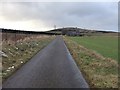
Westerton of Folla
Thanks to Hamish Carr for his assistance.
Image: © Alison Mack
Taken: 21 Jan 2009
0.07 miles
2
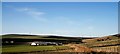
Aberdeenshire vista...
...from the splendidly named Baldyquash Farm: rolling countryside, mixed farming and wind turbines. There are still a few straw rolls to be transferred to barns in this October view. I think we can still just about classify this as 'uplands'.
Image: © Bill Harrison
Taken: 22 Oct 2017
0.16 miles