IMAGES TAKEN NEAR TO
Kemnay, INVERURIE, AB51 5BG
Introduction
This page details the photographs taken nearby to AB51 5BG by members of the Geograph project.
The Geograph project started in 2005 with the aim of publishing, organising and preserving representative images for every square kilometre of Great Britain, Ireland and the Isle of Man.

There are currently over 7.5m images from over14,400 individuals and you can help contribute to the project by visiting https://www.geograph.org.uk
Image Map
Images are licensed for reuse under creativecommons.org/licenses/by-sa/2.0
Notes
- Clicking on the map will re-center to the selected point.
- The higher the marker number, the further away the image location is from the centre of the postcode.
Image Listing (4 Images Found)
Images are licensed for reuse under creativecommons.org/licenses/by-sa/2.0
Image
Details
Distance
1
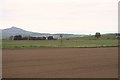
Farmland by Muchalls
Farmland north of Castle Fraser with a view to Bennachie.
Image: © Andrew Wood
Taken: 16 Apr 2011
0.14 miles
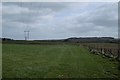
3
Spring arable land, Craigearn
Newly sown.
Image: © Richard Webb
Taken: 5 Apr 2017
0.21 miles
4
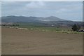
Seedbed and Benachie
Newly sown spring barley (probably) north of Craigearn.
Image: © Richard Webb
Taken: 5 Apr 2017
0.24 miles