IMAGES TAKEN NEAR TO
Hummel Craig, INVERURIE, AB51 4LJ
Introduction
This page details the photographs taken nearby to Hummel Craig, AB51 4LJ by members of the Geograph project.
The Geograph project started in 2005 with the aim of publishing, organising and preserving representative images for every square kilometre of Great Britain, Ireland and the Isle of Man.

There are currently over 7.5m images from over14,400 individuals and you can help contribute to the project by visiting https://www.geograph.org.uk
Image Map
Images are licensed for reuse under creativecommons.org/licenses/by-sa/2.0
Notes
- Clicking on the map will re-center to the selected point.
- The higher the marker number, the further away the image location is from the centre of the postcode.
Image Listing (17 Images Found)
Images are licensed for reuse under creativecommons.org/licenses/by-sa/2.0
Image
Details
Distance
1
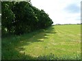
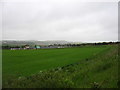
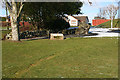
Trees and field
A line of trees separating the outskirts of Inverurie from agricultural land.
Image: © James Allan
Taken: 16 Jun 2008
0.02 miles
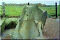
2
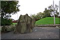
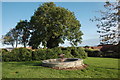
Brandsbutt Stone
The Brandsbutt Stone carved between 500 and 900 AD. Note the mound behind the lamp post.
Image: © stephen samson
Taken: 20 Oct 2006
0.12 miles
3
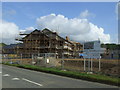
Inverurie Care Village
New development on the outskirts of Inverurie.
Image: © JThomas
Taken: 20 Jul 2014
0.15 miles
5
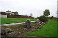
Brandsbutt Stone
The stone and its neighbours once formed part of a stone circle. The circumference of the circle was marked by a circle of cobbles laid in the grass, but the grass, having this unfortunate tendency to keep growing, has now all but hidden the cobbles. You can just about make out a groove in the grass from lower left to the centre of this shot. The information board is clearly visible, and the Brandsbutt Stone itself is in the semi-shade to the right of it. See https://canmore.org.uk/site/18894/brandsbutt-inverurie-symbol-stone for more information.
Image: © Anne Burgess
Taken: 25 Feb 2016
0.23 miles
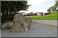
6
Suburban sculpture
A piece of public art entitled "Pieces of a Puzzle" by Jeremy Cunningham enlivens a token slice of green space in the 1990s suburban wasteland of Inverurie.
Image: © Bill Harrison
Taken: 30 Sep 2017
0.24 miles
7
Brandsbutt Stone Circle
Some of the Pictish stones that were recovered from a stone dyke in 1900. The circle was destroyed many years before. They now lie surrounded by a new housing scheme.
Image: © stephen samson
Taken: 20 Oct 2006
0.24 miles
8
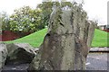
Brandsbutt Stone
This stone has been restored to some extent after its removal
from a dyke around the year 1900. It's a Pictish Symbol Stone. See http://www.aberdeenshire.gov.uk/archaeology/sites/pictish/bransbutt.asp
Image: © stephen samson
Taken: 20 Oct 2006
0.24 miles
9
The Brandsbutt Pictish Stone
Broken and re-assembled.
It bears several standard symbols found on pictish stones including:
a V rod, a Z rod a crescent and a serpent.
In addition there is an ogham inscription: IRATADDOARENS
thought to mean Eddarrnon, possibly St. Ethernanus.
Image: © Bob Embleton
Taken: 11 Aug 2011
0.25 miles
10
Brandsbutt Class I Pictish Symbol Stone
Photograph taken when the stood in a field. https://www.megalithic.co.uk/article.php?sid=7105
Image: © Sandy Gerrard
Taken: Unknown
0.25 miles