IMAGES TAKEN NEAR TO
INVERURIE, AB51 4DL
Introduction
This page details the photographs taken nearby to AB51 4DL by members of the Geograph project.
The Geograph project started in 2005 with the aim of publishing, organising and preserving representative images for every square kilometre of Great Britain, Ireland and the Isle of Man.

There are currently over 7.5m images from over14,400 individuals and you can help contribute to the project by visiting https://www.geograph.org.uk
Image Map
Images are licensed for reuse under creativecommons.org/licenses/by-sa/2.0
Notes
- Clicking on the map will re-center to the selected point.
- The higher the marker number, the further away the image location is from the centre of the postcode.
Image Listing (17 Images Found)
Images are licensed for reuse under creativecommons.org/licenses/by-sa/2.0
Image
Details
Distance
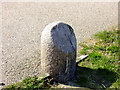
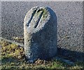
1
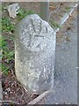
Old Milestone by the B9001, Inverurie
Double bevel milestone by the B9001, in parish of Iverurie (Grampian District), Inverurie, South of railway bridge and Howford Bridge over the River Urie.
Inscription reads:-
: Ab / 17 : : In / 1 :
(To Aberdeen and Inverurie)
Surveyed
Milestone Society National ID: AD_ADIU17
Image: © Milestone Society
Taken: Unknown
0.04 miles
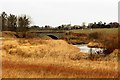
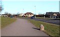
3
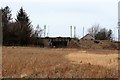
Howford Rail Bridge
A bridge to the north of Inverurie Station carrying the B9170 over the line.
Image: © Andrew Wood
Taken: 19 Feb 2020
0.08 miles
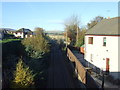
4
Inverurie to Inverness line
Looking toward Inverurie railway station from the side of the bridge over the line.
Image: © Ralph Greig
Taken: 27 Dec 2021
0.08 miles
5
Old milestone
Many of the original routes spreading out from the city of Aberdeen to other important towns have been changed and upgraded over the years. This 17 mile single-bevelled granite stone is now on the unclassified North Street from which it is still possible to follow a route towards Huntly, Keith and the Moray Firth. Another stone in this Grid Square is one of the rare double-bevelled stones giving mileages to Inverurie (In 1) and Aberdeen (Ab 17).
Image: © Chris McBrien
Taken: 17 Apr 2021
0.14 miles
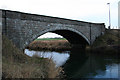
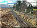
8
Howford Bridge
A road bridge on the outskirts of Inverurie carrying the B9170 over the River Urie.
Image: © Andrew Wood
Taken: 19 Feb 2020
0.15 miles
9
Milestone, North Street, Inverurie
17 miles from Aberdeen
Image]
Image: © Bob Embleton
Taken: 3 Mar 2015
0.16 miles
10
Milestone on North Street, Inverurie
The old granite block bears the number "17", being 17 miles from Aberdeen.
Image]
Image: © Bob Embleton
Taken: 3 Mar 2015
0.16 miles