IMAGES TAKEN NEAR TO
Cobbans Lane, INVERURIE, AB51 4AU
Introduction
This page details the photographs taken nearby to Cobbans Lane, AB51 4AU by members of the Geograph project.
The Geograph project started in 2005 with the aim of publishing, organising and preserving representative images for every square kilometre of Great Britain, Ireland and the Isle of Man.

There are currently over 7.5m images from over14,400 individuals and you can help contribute to the project by visiting https://www.geograph.org.uk
Image Map
Images are licensed for reuse under creativecommons.org/licenses/by-sa/2.0
Notes
- Clicking on the map will re-center to the selected point.
- The higher the marker number, the further away the image location is from the centre of the postcode.
Image Listing (31 Images Found)
Images are licensed for reuse under creativecommons.org/licenses/by-sa/2.0
Image
Details
Distance
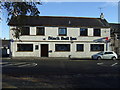
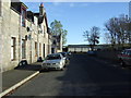
2
Suburban corner, Inverurie
The meeting point of Garioch Road and Mortimer's Lane with Harlaw Road.
Image: © Bill Harrison
Taken: 19 Aug 2012
0.09 miles
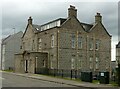
3
Former Drawing Office for Inverurie Loco Works
Derelict for 40 years since the works closed in 1969, now being restored. B-listed: http://www.britishlistedbuildings.co.uk/sc-49302-former-manager-s-drawing-office-former-gr
Image: © Bill Harrison
Taken: 19 Aug 2012
0.10 miles
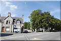
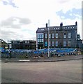
6
Manager?s Office and Drawing Office, Inverurie railway works
Early 20th century, built as part of the new works of the Great North of Scotland Railway. Designed by William Pickersgill, Listed Category B.
Image: © Alan Murray-Rust
Taken: 22 May 2022
0.12 miles
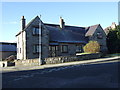
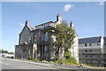
9
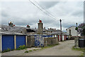
Inside the Colonies
The colonies are seven blocks of housing built by the railway for some of the workers in the locomotive works. They were superior to other housing of the period, with four flats off each common stair, electricity supplied by the railway company, and indoor toilets, though the toilets were not inside the individual flats but opened separately off the stairs. Each group of flats had a front entrance on the street, a rear entrance to a back green with a coal shed for each flat and a communal wash-house with a copper. The low building with a chimney left of centre is one of the wash-houses. Later on, garages were built on many of the back greens.
Image: © Anne Burgess
Taken: 22 May 2022
0.13 miles
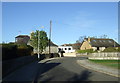
10
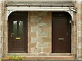
6 & 7 Harlaw Road, Inverurie
Detail showing the cast iron valance to the porch canopy. See https://www.geograph.org.uk/photo/7183972 for location
Image: © Alan Murray-Rust
Taken: 22 May 2022
0.14 miles