IMAGES TAKEN NEAR TO
North Street, INVERURIE, AB51 4AE
Introduction
This page details the photographs taken nearby to North Street, AB51 4AE by members of the Geograph project.
The Geograph project started in 2005 with the aim of publishing, organising and preserving representative images for every square kilometre of Great Britain, Ireland and the Isle of Man.

There are currently over 7.5m images from over14,400 individuals and you can help contribute to the project by visiting https://www.geograph.org.uk
Image Map
Images are licensed for reuse under creativecommons.org/licenses/by-sa/2.0
Notes
- Clicking on the map will re-center to the selected point.
- The higher the marker number, the further away the image location is from the centre of the postcode.
Image Listing (4 Images Found)
Images are licensed for reuse under creativecommons.org/licenses/by-sa/2.0
Image
Details
Distance
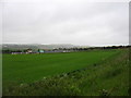
1
Trees and field
A line of trees separating the outskirts of Inverurie from agricultural land.
Image: © James Allan
Taken: 16 Jun 2008
0.10 miles
2
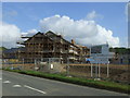
Inverurie Care Village
New development on the outskirts of Inverurie.
Image: © JThomas
Taken: 20 Jul 2014
0.14 miles
3
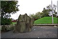
Brandsbutt Stone
The Brandsbutt Stone carved between 500 and 900 AD. Note the mound behind the lamp post.
Image: © stephen samson
Taken: 20 Oct 2006
0.18 miles