IMAGES TAKEN NEAR TO
Wallace Road, INVERURIE, AB51 3YF
Introduction
This page details the photographs taken nearby to Wallace Road, AB51 3YF by members of the Geograph project.
The Geograph project started in 2005 with the aim of publishing, organising and preserving representative images for every square kilometre of Great Britain, Ireland and the Isle of Man.

There are currently over 7.5m images from over14,400 individuals and you can help contribute to the project by visiting https://www.geograph.org.uk
Image Map
Images are licensed for reuse under creativecommons.org/licenses/by-sa/2.0
Notes
- Clicking on the map will re-center to the selected point.
- The higher the marker number, the further away the image location is from the centre of the postcode.
Image Listing (69 Images Found)
Images are licensed for reuse under creativecommons.org/licenses/by-sa/2.0
Image
Details
Distance
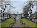
2
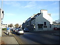
High Street, Inverurie (B9001)
Heading north.
Image: © JThomas
Taken: 9 Nov 2013
0.07 miles

5
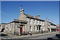
Former Clydesdale Bank, High Street, Inverurie
B-listed: http://www.britishlistedbuildings.co.uk/sc-35393-clydesdale-bank-1-high-street-
Image: © Bill Harrison
Taken: 19 Aug 2012
0.08 miles
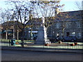
6
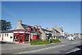
Market Place, Inverurie
Roma Italian Restaurant in red at the corner...
Image: © Bill Harrison
Taken: 19 Aug 2012
0.08 miles
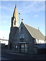
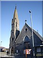
7

Inverurie Gospel Hall
On High Street (B9001).
Image: © Stanley Howe
Taken: 22 Feb 2018
0.10 miles