IMAGES TAKEN NEAR TO
Selbie Drive, INVERURIE, AB51 3YD
Introduction
This page details the photographs taken nearby to Selbie Drive, AB51 3YD by members of the Geograph project.
The Geograph project started in 2005 with the aim of publishing, organising and preserving representative images for every square kilometre of Great Britain, Ireland and the Isle of Man.

There are currently over 7.5m images from over14,400 individuals and you can help contribute to the project by visiting https://www.geograph.org.uk
Image Map
Images are licensed for reuse under creativecommons.org/licenses/by-sa/2.0
Notes
- Clicking on the map will re-center to the selected point.
- The higher the marker number, the further away the image location is from the centre of the postcode.
Image Listing (5 Images Found)
Images are licensed for reuse under creativecommons.org/licenses/by-sa/2.0
Image
Details
Distance
1
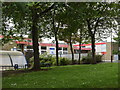
Kellands Primary School, Inverurie
School roll (2020): 440 plus 80 nursery places.
Image: © Bill Harrison
Taken: 24 Jun 2020
0.08 miles
2
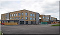
Inverurie Community Campus
Ready to replace Inverurie Academy (secondary school) after the coronavirus crisis of 2020.
Image: © Bill Harrison
Taken: 24 Jun 2020
0.19 miles
3
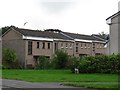
Houses on Blackhall Road
Part of the large expansion of Inverurie in recent years.
Image: © Richard Webb
Taken: 6 Aug 2011
0.21 miles
5
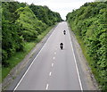
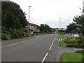
Bikers on the A96
The long-term plan is for a dual-carriageway all the way from Aberdeen to Inverness.
Image: © Bill Harrison
Taken: 24 Jun 2020
0.25 miles