IMAGES TAKEN NEAR TO
Kintore, INVERURIE, AB51 0YY
Introduction
This page details the photographs taken nearby to AB51 0YY by members of the Geograph project.
The Geograph project started in 2005 with the aim of publishing, organising and preserving representative images for every square kilometre of Great Britain, Ireland and the Isle of Man.

There are currently over 7.5m images from over14,400 individuals and you can help contribute to the project by visiting https://www.geograph.org.uk
Image Map
Images are licensed for reuse under creativecommons.org/licenses/by-sa/2.0
Notes
- Clicking on the map will re-center to the selected point.
- The higher the marker number, the further away the image location is from the centre of the postcode.
Image Listing (5 Images Found)
Images are licensed for reuse under creativecommons.org/licenses/by-sa/2.0
Image
Details
Distance
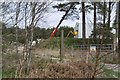
3
Woodland, Cottown
Wetland wood by the B994.
Image: © Richard Webb
Taken: 5 Apr 2017
0.10 miles
4
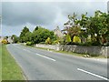
Upper Cottown
Roadside houses on the B994 in Upper Cottown.
Image: © James Allan
Taken: 15 Jun 2008
0.15 miles
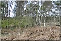
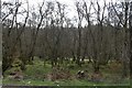
5
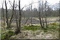
Wet woodland, Cottown
Damp underfoot, but being dried out by birch colonisation.
Image: © Richard Webb
Taken: 5 Apr 2017
0.19 miles