IMAGES TAKEN NEAR TO
Kintore, INVERURIE, AB51 0YT
Introduction
This page details the photographs taken nearby to AB51 0YT by members of the Geograph project.
The Geograph project started in 2005 with the aim of publishing, organising and preserving representative images for every square kilometre of Great Britain, Ireland and the Isle of Man.

There are currently over 7.5m images from over14,400 individuals and you can help contribute to the project by visiting https://www.geograph.org.uk
Image Map
Images are licensed for reuse under creativecommons.org/licenses/by-sa/2.0
Notes
- Clicking on the map will re-center to the selected point.
- The higher the marker number, the further away the image location is from the centre of the postcode.
Image Listing (3 Images Found)
Images are licensed for reuse under creativecommons.org/licenses/by-sa/2.0
Image
Details
Distance
1
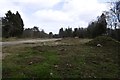
Possible construction, Craigmyle
A cleared bit of woodland with ground works.
Image: © Richard Webb
Taken: 5 Apr 2017
0.22 miles
3
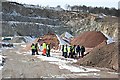
Tom's Forest Quarry
The quarry workings have extended well to the west of the area currently shown on the map as quarry workings. The main product is produced from the grey granite in the background, but the reddish material is pink granite from Corrennie Quarry which is brought to Tom's Forest for processing.
Image: © Anne Burgess
Taken: 25 Mar 2008
0.24 miles