IMAGES TAKEN NEAR TO
Tumulus Way, INVERURIE, AB51 0TG
Introduction
This page details the photographs taken nearby to Tumulus Way, AB51 0TG by members of the Geograph project.
The Geograph project started in 2005 with the aim of publishing, organising and preserving representative images for every square kilometre of Great Britain, Ireland and the Isle of Man.

There are currently over 7.5m images from over14,400 individuals and you can help contribute to the project by visiting https://www.geograph.org.uk
Image Map
Images are licensed for reuse under creativecommons.org/licenses/by-sa/2.0
Notes
- Clicking on the map will re-center to the selected point.
- The higher the marker number, the further away the image location is from the centre of the postcode.
Image Listing (5 Images Found)
Images are licensed for reuse under creativecommons.org/licenses/by-sa/2.0
Image
Details
Distance

2

Industrial unit, Midmill Business Park, Kintore
It looks almost new but is out of use and 'to let'.
Image: © Bill Harrison
Taken: 22 Apr 2020
0.15 miles
3
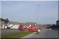
Too new for the map
The access road does not appear to be complete, but the first few houses are already occupied...
Image: © Bill Harrison
Taken: 26 Mar 2012
0.22 miles
4

Office block, Midmill Business Park, Kintore
Image: © Bill Harrison
Taken: 22 Apr 2020
0.22 miles
5

Looking down Tofthills Avenue, Midmill Business Park, Kintore
Image: © Bill Harrison
Taken: 22 Apr 2020
0.22 miles