IMAGES TAKEN NEAR TO
Mackenzie Drive, INVERURIE, AB51 0NR
Introduction
This page details the photographs taken nearby to Mackenzie Drive, AB51 0NR by members of the Geograph project.
The Geograph project started in 2005 with the aim of publishing, organising and preserving representative images for every square kilometre of Great Britain, Ireland and the Isle of Man.

There are currently over 7.5m images from over14,400 individuals and you can help contribute to the project by visiting https://www.geograph.org.uk
Image Map
Images are licensed for reuse under creativecommons.org/licenses/by-sa/2.0
Notes
- Clicking on the map will re-center to the selected point.
- The higher the marker number, the further away the image location is from the centre of the postcode.
Image Listing (12 Images Found)
Images are licensed for reuse under creativecommons.org/licenses/by-sa/2.0
Image
Details
Distance
1
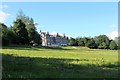
House of Daviot
From country house to hospital and then back into private accommodation this house sits dominantly in its own woodland.
Image: © Andrew Wood
Taken: 30 Jun 2020
0.01 miles
2
Daviot Doocots
What appears to be two dovecotes in the grounds of House of Daviot.
Image: © Andrew Wood
Taken: 30 Jun 2020
0.09 miles
3
Daviot Pumphouse
A disused building by a pool in ground by Daviot House.
Image: © Andrew Wood
Taken: 3 Mar 2021
0.11 miles
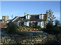
4
Stable Close
Now converted into housing this was once an estate building quad.
Image: © Andrew Wood
Taken: 30 Jun 2020
0.12 miles
5
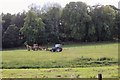
Fencing Tractors
Not potential swordplay but part of installing a new field division at Daviot.
Image: © Andrew Wood
Taken: 30 Jun 2020
0.13 miles
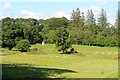
6
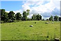
Sheep by Stable Close
A small patch of farmland in an area becoming largely built up, even the old farmstead behind has been converted into housing.
Image: © Andrew Wood
Taken: 30 Jun 2020
0.14 miles
8
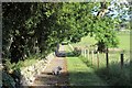
Down Holly Tree Walk
A path leading downhill beside House of Daviot on the circular walk.
Image: © Andrew Wood
Taken: 30 Jun 2020
0.15 miles
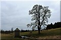
9
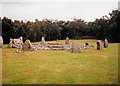
Loanhead of Daviot
Neolithic recumbent stone circle. See http://www.aberdeenshire.gov.uk/archaeology/sites/stonecircles/loanhead.asp
Image: © Paul Allison
Taken: Unknown
0.19 miles
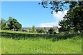
10
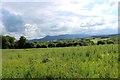
Weedy Paddock
Grassland at Daviot, once part of the estate this seems a little neglected now. Its location in front of what was a farm steading and stable block would have been kept tidy in the past.
Image: © Andrew Wood
Taken: 30 Jun 2020
0.20 miles