IMAGES TAKEN NEAR TO
Keith Hall, INVERURIE, AB51 0LZ
Introduction
This page details the photographs taken nearby to AB51 0LZ by members of the Geograph project.
The Geograph project started in 2005 with the aim of publishing, organising and preserving representative images for every square kilometre of Great Britain, Ireland and the Isle of Man.

There are currently over 7.5m images from over14,400 individuals and you can help contribute to the project by visiting https://www.geograph.org.uk
Image Map
Images are licensed for reuse under creativecommons.org/licenses/by-sa/2.0
Notes
- Clicking on the map will re-center to the selected point.
- The higher the marker number, the further away the image location is from the centre of the postcode.
Image Listing (7 Images Found)
Images are licensed for reuse under creativecommons.org/licenses/by-sa/2.0
Image
Details
Distance
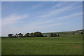
1
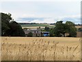
Altons Farm
Altons with its sheltering trees behind a ripening crop.
Image: © Andrew Wood
Taken: 7 Aug 2018
0.02 miles
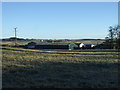
3
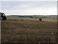
Harvested field at Altons
Looking north-east over a harvested potato field at Altons.
Image: © Scott Cormie
Taken: 28 Aug 2023
0.06 miles
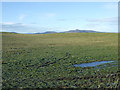
5
Fields by Altons
Open fields by Altons near Kinmuck.
Image: © Andrew Wood
Taken: 4 May 2011
0.18 miles