IMAGES TAKEN NEAR TO
INVERURIE, AB51 0LU
Introduction
This page details the photographs taken nearby to AB51 0LU by members of the Geograph project.
The Geograph project started in 2005 with the aim of publishing, organising and preserving representative images for every square kilometre of Great Britain, Ireland and the Isle of Man.

There are currently over 7.5m images from over14,400 individuals and you can help contribute to the project by visiting https://www.geograph.org.uk
Image Map
Images are licensed for reuse under creativecommons.org/licenses/by-sa/2.0
Notes
- Clicking on the map will re-center to the selected point.
- The higher the marker number, the further away the image location is from the centre of the postcode.
Image Listing (6 Images Found)
Images are licensed for reuse under creativecommons.org/licenses/by-sa/2.0
Image
Details
Distance
1
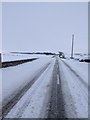
Winter Chill
B993 (Inverurie to Whiterashes) at Kinkell covered in Late Winter/Early Spring Snow.
Image: © Ian Hindmarsh
Taken: 3 Mar 2006
0.02 miles
2
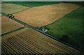
Kinkell Cottages
Kinkell Cottages late summer taken from the air in an Auster light plane transiting from Insch Airfield to the airstrip at Bogfechel near Whiterashes.
Image: © Ian Hindmarsh
Taken: Unknown
0.03 miles