IMAGES TAKEN NEAR TO
INVERURIE, AB51 0JP
Introduction
This page details the photographs taken nearby to AB51 0JP by members of the Geograph project.
The Geograph project started in 2005 with the aim of publishing, organising and preserving representative images for every square kilometre of Great Britain, Ireland and the Isle of Man.

There are currently over 7.5m images from over14,400 individuals and you can help contribute to the project by visiting https://www.geograph.org.uk
Image Map
Images are licensed for reuse under creativecommons.org/licenses/by-sa/2.0
Notes
- Clicking on the map will re-center to the selected point.
- The higher the marker number, the further away the image location is from the centre of the postcode.
Image Listing (4 Images Found)
Images are licensed for reuse under creativecommons.org/licenses/by-sa/2.0
Image
Details
Distance
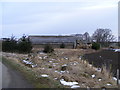
1
Lochend of Barra
The bare ribs of a polytunnel stand beside the barns at Lochend.
Image: © Anne Burgess
Taken: 18 Feb 2016
0.11 miles
3
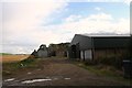
Lochend Steadings
Farm buildings at Lochend of Barra.
Image: © Andrew Wood
Taken: 5 Sep 2011
0.14 miles
4
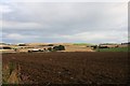
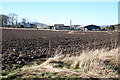
Fields by Lochend
A ploughed field by Lochend of Barra with the farm by the trees.
Image: © Andrew Wood
Taken: 5 Sep 2011
0.16 miles