IMAGES TAKEN NEAR TO
INVERURIE, AB51 0HN
Introduction
This page details the photographs taken nearby to AB51 0HN by members of the Geograph project.
The Geograph project started in 2005 with the aim of publishing, organising and preserving representative images for every square kilometre of Great Britain, Ireland and the Isle of Man.

There are currently over 7.5m images from over14,400 individuals and you can help contribute to the project by visiting https://www.geograph.org.uk
Image Map
Images are licensed for reuse under creativecommons.org/licenses/by-sa/2.0
Notes
- Clicking on the map will re-center to the selected point.
- The higher the marker number, the further away the image location is from the centre of the postcode.
Image Listing (5 Images Found)
Images are licensed for reuse under creativecommons.org/licenses/by-sa/2.0
Image
Details
Distance
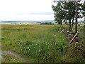
1
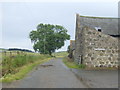
Shadowside
A farm named, perhaps, after the aspect of the buildings relative to the higher ground to the south. The lane heads east towards Smithycroft.
Image: © Jonathan Billinger
Taken: 17 Jul 2007
0.02 miles
3
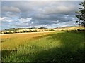
Bourtie Field
A field of ripening barley by Bourtie with behind the ground rising to Barra Hill on the left and Lawel Hill.
Image: © Andrew Wood
Taken: 31 Jul 2018
0.22 miles
4
Smithycroft donkey
This photogenic creature grazes on the westernmost slope of Lawel Hill.
Image: © Jonathan Billinger
Taken: 17 Jul 2007
0.24 miles
5
View north of Bourtie
Looking across rolling Buchan countryside.
Image: © Jonathan Billinger
Taken: 17 Jul 2007
0.25 miles