IMAGES TAKEN NEAR TO
INVERURIE, AB51 0HL
Introduction
This page details the photographs taken nearby to AB51 0HL by members of the Geograph project.
The Geograph project started in 2005 with the aim of publishing, organising and preserving representative images for every square kilometre of Great Britain, Ireland and the Isle of Man.

There are currently over 7.5m images from over14,400 individuals and you can help contribute to the project by visiting https://www.geograph.org.uk
Image Map
Images are licensed for reuse under creativecommons.org/licenses/by-sa/2.0
Notes
- Clicking on the map will re-center to the selected point.
- The higher the marker number, the further away the image location is from the centre of the postcode.
Image Listing (9 Images Found)
Images are licensed for reuse under creativecommons.org/licenses/by-sa/2.0
Image
Details
Distance
1
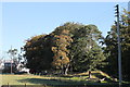
Tullochmor Trees
Woodland at Tullochmor by Portstown and a glimpse of nearby industrial units.
Image: © Andrew Wood
Taken: 9 Oct 2016
0.08 miles
2
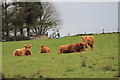
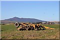
Cattle by Hillcrest
Highland cattle at ease in a field by Hillcrest.
Image: © Andrew Wood
Taken: 27 Apr 2015
0.10 miles
4
Collyhill highlanders
Highland cattle at Collyhill in field beside the junction of the Lethenty road and Oldmeldrum road near Inverurie.
Image: © Andrew Wood
Taken: 8 Mar 2009
0.14 miles
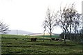
5
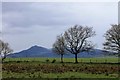
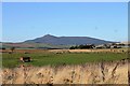
Trees by Hillcrest
Just to the west of Hillcrest if the crest of the hill with trees and in the background Bennachie.
Image: © Andrew Wood
Taken: 27 Apr 2015
0.14 miles
8
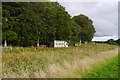
Portstown Machinery
Farming equipment at Portstown Farm.
Image: © Andrew Wood
Taken: 9 Oct 2016
0.23 miles
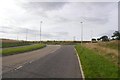
9
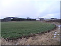
Grassland in Peril
Grassland at Portstown Farm, still used for grazing occasionally this is going to be developed very soon.
Image: © Andrew Wood
Taken: 9 Oct 2016
0.24 miles