IMAGES TAKEN NEAR TO
Oldmeldrum, INVERURIE, AB51 0BY
Introduction
This page details the photographs taken nearby to AB51 0BY by members of the Geograph project.
The Geograph project started in 2005 with the aim of publishing, organising and preserving representative images for every square kilometre of Great Britain, Ireland and the Isle of Man.

There are currently over 7.5m images from over14,400 individuals and you can help contribute to the project by visiting https://www.geograph.org.uk
Image Map
Images are licensed for reuse under creativecommons.org/licenses/by-sa/2.0
Notes
- Clicking on the map will re-center to the selected point.
- The higher the marker number, the further away the image location is from the centre of the postcode.
Image Listing (3 Images Found)
Images are licensed for reuse under creativecommons.org/licenses/by-sa/2.0
Image
Details
Distance
1
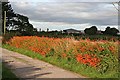
Montbretia (Crocosmia x crocosmiiflora)
This bank of Montbretia at Redmoss was strikingly lit by late afternoon sunshine.
Image: © Anne Burgess
Taken: 19 Sep 2008
0.06 miles
2
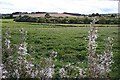
Red Moss
This turns out to be an amazingly awkward square to get to from this corner, because Redmoss Farm obviously keeps horses, and therefore needs to have electric fences. The wooded area is mapped as scrubland, and is very probably wet ground. The Rosebay Willowherb on the field margin was producing a veritable snowstorm of feathery seeds.
Image: © Anne Burgess
Taken: 19 Sep 2008
0.22 miles
3
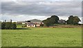
Moss-side Farm
This is a large mixed farm with several cottages. The farmhouse is among the trees.
Image: © Anne Burgess
Taken: 19 Sep 2008
0.25 miles