IMAGES TAKEN NEAR TO
Oldmeldrum, INVERURIE, AB51 0BH
Introduction
This page details the photographs taken nearby to AB51 0BH by members of the Geograph project.
The Geograph project started in 2005 with the aim of publishing, organising and preserving representative images for every square kilometre of Great Britain, Ireland and the Isle of Man.

There are currently over 7.5m images from over14,400 individuals and you can help contribute to the project by visiting https://www.geograph.org.uk
Image Map
Images are licensed for reuse under creativecommons.org/licenses/by-sa/2.0
Notes
- Clicking on the map will re-center to the selected point.
- The higher the marker number, the further away the image location is from the centre of the postcode.
Image Listing (10 Images Found)
Images are licensed for reuse under creativecommons.org/licenses/by-sa/2.0
Image
Details
Distance
1
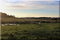
Twin Ponds
Two ponds at Greenford fed by the Meadow Burn.
Image: © Andrew Wood
Taken: 8 Aug 2020
0.06 miles
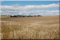
3
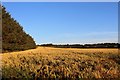
Wheat Field by Greenford
Wheat in a field near Greenford which lies, out of photo, to the right.
Image: © Andrew Wood
Taken: 8 Aug 2020
0.12 miles
5
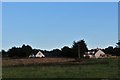
Greenford Mill
On the map as Greenford Mill but certainly housing now.
Image: © Andrew Wood
Taken: 8 Aug 2020
0.17 miles
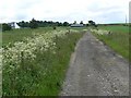
6
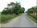
Back road near Philipstown
Country road from Bourtrie towards the A947.
Image: © James Allan
Taken: 18 Jun 2008
0.20 miles
7
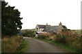
Woodside
On a bend by Fordalehouse Wood, Woodside lives up to its name.
Image: © Andrew Wood
Taken: 30 Sep 2008
0.21 miles
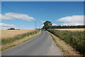
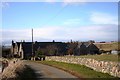
8
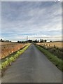
Minor road near Philipstown
Minor road linking the small communities to the south of Oldmeldrum with the A947.
Image: © David Robinson
Taken: 25 Sep 2018
0.21 miles
9
View over the fields towards Scoutbog Steading
Image: © Bill Harrison
Taken: 9 Aug 2015
0.25 miles
10
Scoutbog Steading
The converted steading of Scoutbog. Once a smallholding on the edge of Oldmeldrum,Scoutbog is now another rural housing complex.
Image: © Andrew Wood
Taken: 14 Mar 2009
0.25 miles