IMAGES TAKEN NEAR TO
Main Street, BANFF, AB45 3YP
Introduction
This page details the photographs taken nearby to Main Street, AB45 3YP by members of the Geograph project.
The Geograph project started in 2005 with the aim of publishing, organising and preserving representative images for every square kilometre of Great Britain, Ireland and the Isle of Man.

There are currently over 7.5m images from over14,400 individuals and you can help contribute to the project by visiting https://www.geograph.org.uk
Image Map
Images are licensed for reuse under creativecommons.org/licenses/by-sa/2.0
Notes
- Clicking on the map will re-center to the selected point.
- The higher the marker number, the further away the image location is from the centre of the postcode.
Image Listing (89 Images Found)
Images are licensed for reuse under creativecommons.org/licenses/by-sa/2.0
Image
Details
Distance
1
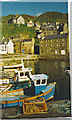
Gardenstown Harbour
Gardenstown harbour is approached by a very steep and serpentine road from the clifftop.
Image: © Colin Smith
Taken: 1 Apr 2000
0.01 miles
2
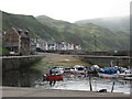
Harbour and seatown at Gardenstown (Gamrie)
Image: © Ulrich Hartmann
Taken: 23 Aug 2007
0.03 miles
3
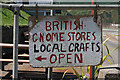
This Way for Local Crafts
When one gets there, there is a fine motley collection of bric-à-brac.
Image: © Anne Burgess
Taken: 25 Jul 2014
0.04 miles
4
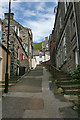
Strait Path
This steep lane leads up eventually to the High Street.
Image: © Anne Burgess
Taken: 9 Jun 2014
0.04 miles
5
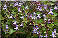
Ivy-leaved Toadflax (Cymbalaria muralis)
One of several patches growing on a wall below the level of the High Street. It's so common that it came as a surprise to read that apparently it is not native to Britain, but was introduced and first noted in Essex in 1617!
Image: © Anne Burgess
Taken: 9 Jun 2014
0.04 miles
6
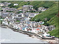
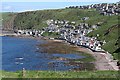
Gardenstown Aberdeenshire
Gardenstown viewed from the cliff footpath to the east of the village.
Image: © Ian Smith
Taken: 12 Jul 2007
0.04 miles
7
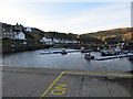
Gardenstown and its Harbour
Looking south-westward.
Image: © Peter Wood
Taken: 17 Nov 2019
0.04 miles
8
Section of 139 Church Road, Gardenstown showing OS Cut Mark
Section of 139 Church Road, Gardenstown showing clear OS Cut Mark
Image: © thejackrustles
Taken: 19 Jul 2015
0.05 miles
9
Gardenstown
Looking down from beside St John's Kirk, the division of the village into two parts is obvious.
Image: © Anne Burgess
Taken: 15 May 2007
0.05 miles
10
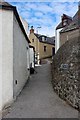
Strait Path
The windy lane that's Strait Path, leading up from Harbour Road.
Image: © Andrew Wood
Taken: 21 Jul 2020
0.05 miles