IMAGES TAKEN NEAR TO
BANFF, AB45 3YA
Introduction
This page details the photographs taken nearby to AB45 3YA by members of the Geograph project.
The Geograph project started in 2005 with the aim of publishing, organising and preserving representative images for every square kilometre of Great Britain, Ireland and the Isle of Man.

There are currently over 7.5m images from over14,400 individuals and you can help contribute to the project by visiting https://www.geograph.org.uk
Image Map
Images are licensed for reuse under creativecommons.org/licenses/by-sa/2.0
Notes
- Clicking on the map will re-center to the selected point.
- The higher the marker number, the further away the image location is from the centre of the postcode.
Image Listing (5 Images Found)
Images are licensed for reuse under creativecommons.org/licenses/by-sa/2.0
Image
Details
Distance
3
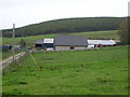
Near Lower Deuchries
On the left is Burngrains, and in the distance, on the right, is the oddly named Commissarybog.
Image: © Anne Burgess
Taken: 1 Nov 2011
0.18 miles
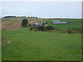
4
Road near Cooperhill
Minor road heading north near Cooperhill.
Image: © Scott Cormie
Taken: 7 May 2022
0.19 miles
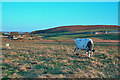
5
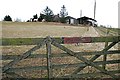
Little Cooperhill
The closed gate is to keep in the horses which are watching me from just beside the farm house.
Image: © Anne Burgess
Taken: 27 Feb 2008
0.23 miles