IMAGES TAKEN NEAR TO
Alvah, BANFF, AB45 3UP
Introduction
This page details the photographs taken nearby to AB45 3UP by members of the Geograph project.
The Geograph project started in 2005 with the aim of publishing, organising and preserving representative images for every square kilometre of Great Britain, Ireland and the Isle of Man.

There are currently over 7.5m images from over14,400 individuals and you can help contribute to the project by visiting https://www.geograph.org.uk
Image Map
Images are licensed for reuse under creativecommons.org/licenses/by-sa/2.0
Notes
- Clicking on the map will re-center to the selected point.
- The higher the marker number, the further away the image location is from the centre of the postcode.
Image Listing (4 Images Found)
Images are licensed for reuse under creativecommons.org/licenses/by-sa/2.0
Image
Details
Distance
1
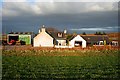
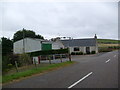
Itlaw Smithy
The present owners run an agricultural engineering business, thus sticking to the general purpose of the original building. The gable end is a modern extension to the old house.
Image: © Anne Burgess
Taken: 23 Mar 2007
0.01 miles
4
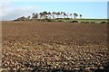
Hill near Bagrae
The hill is unnamed on the maps.
Image: © Anne Burgess
Taken: 23 Mar 2007
0.25 miles