IMAGES TAKEN NEAR TO
Alvah, BANFF, AB45 3TT
Introduction
This page details the photographs taken nearby to AB45 3TT by members of the Geograph project.
The Geograph project started in 2005 with the aim of publishing, organising and preserving representative images for every square kilometre of Great Britain, Ireland and the Isle of Man.

There are currently over 7.5m images from over14,400 individuals and you can help contribute to the project by visiting https://www.geograph.org.uk
Image Map
Images are licensed for reuse under creativecommons.org/licenses/by-sa/2.0
Notes
- Clicking on the map will re-center to the selected point.
- The higher the marker number, the further away the image location is from the centre of the postcode.
Image Listing (4 Images Found)
Images are licensed for reuse under creativecommons.org/licenses/by-sa/2.0
Image
Details
Distance
1
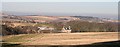
Tipperty
Seen from the woods just above the picnic site, it isn't obvious that the main A97 passes between the farm and the photographer location. In the distance, on the right, are the outskirts of Banff.
Image: © Anne Burgess
Taken: 11 Feb 2008
0.03 miles
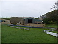
3
Tipperty
From the B9121 the size of Tipprty Farm becomes evident.
Image: © Anne Burgess
Taken: 11 Feb 2008
0.06 miles