IMAGES TAKEN NEAR TO
BANFF, AB45 3TP
Introduction
This page details the photographs taken nearby to AB45 3TP by members of the Geograph project.
The Geograph project started in 2005 with the aim of publishing, organising and preserving representative images for every square kilometre of Great Britain, Ireland and the Isle of Man.

There are currently over 7.5m images from over14,400 individuals and you can help contribute to the project by visiting https://www.geograph.org.uk
Image Map
Images are licensed for reuse under creativecommons.org/licenses/by-sa/2.0
Notes
- Clicking on the map will re-center to the selected point.
- The higher the marker number, the further away the image location is from the centre of the postcode.
Image Listing (4 Images Found)
Images are licensed for reuse under creativecommons.org/licenses/by-sa/2.0
Image
Details
Distance
1
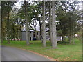
New Houses at Colleonard
Modern houses stand by the minor road above Mains of Colleonard.
Image: © Anne Burgess
Taken: 24 Feb 2011
0.18 miles
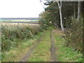
2
Mains of Colleonard
Looking down from the minor road on Hill of Boyndie to the buildings around Mains of Colleonard. Colleonard House itself is partly hidden among the trees on the left.
Image: © Anne Burgess
Taken: 24 Feb 2011
0.18 miles